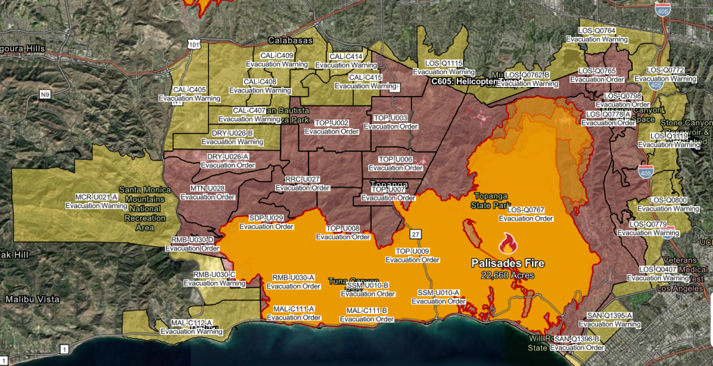
See maps of where mandatory evacuation orders as well as warnings are in place for wildfires burning in the Los Angeles area.
A deadly outbreak of wildfires in the Los Angeles region has prompted active evacuation orders for over 153,000 people Saturday, Los Angeles County Sheriff Robert Luna said at a news conference.
Evacuation warnings say 166,000 others residents should be prepared to flee. At least 57,000 structures are at risk and at 38,000 acres of land have been scorched from the blazes, including the Palisades Fire, the most destructive in Los Angeles’s history.
Forecasters are warning that gusty winds will further pose dangerous conditions going into next week.
Alana Alejo, a Target security officer who has lived in LA since 2007, evacuated her home in the Encino neighborhood Friday. She said she decided to leave before an evacuation order was placed after seeing ashes in the air. She left taking valuables, a panicked pet hamster and an emergency food supply she had prepared for a moment like this.
ADVERTISEMENT
“I was panicking trying to be calm,” Alejo told USA TODAY Friday night outside the Lanark Recreation Center evacuation spot. “It’s really hard seeing this happen. I have other friends that have lost, they lost their houses, like it’s completely flat. This is very real.”
Here’s where evacuation orders are in place for California as of Saturday afternoon and how to stay up-to-date on the latest.
Where are evacuation orders in place for the Palisades Fire?
Evacuation orders were in place in Los Angeles County from Malibu to Santa Monica, including Topanga State Park and stretching into the city as far south as Montana Avenue in Santa Monica, as of about 2 p.m. PT Saturday, according to Cal Fire.
Evacuation warnings were in place north, west and just southeast of those areas.
Per the the Los Angeles County Sheriff’s Department: all evacuation orders and warning areas for the fire are under curfew from 6 p.m. Friday through 6 a.m. Saturday, Cal Fire reported.
ADVERTISEMENT
View an interactive map of Palisades Fire evacuation orders and warnings on the Cal Fire website.

Where are evacuation orders in place for the Eaton Fire?
Evacuation orders were in place, as Saturday afternoon, for areas near Altadena and Pasadena, Cal Fire reported, particularly the area north of Orange Grove and Rosemead Boulevard, east of Lake Avenue, and west of Michillinda Avenue.
Evacuation warnings were in place for areas just west and south of the area.
View an interactive map of Eaton Fire evacuation orders and warnings on the Cal Fire website.

Why not use ocean water to fight fires? Lack of water is hampering LA fire battle.
Where are evacuation orders in place for the Hurst Fire?
Evacuation orders and warnings for the Hurst fire have been lifted Friday afternoon, according to Cal Fire.
ADVERTISEMENT
View an interactive map of Hurst Fire evacuation orders and warnings on the Cal Fire website.
Where are evacuation orders in place for the Kenneth Fire?
Evacuation orders and warnings had been lifted Friday afternoon, for the Kenneth Fire, affecting both Los Angeles and Ventura counties.
View an interactive map of Kenneth Fire evacuation orders and warnings on the Cal Fire website.
Contributing: James Powel and Jeanine Santucci
This article originally appeared on USA TODAY: Evacuation maps for Los Angeles fires: Here’s where orders are issued


